
An end to widespread freezing conditions is in sight as a gradual thaw takes hold of the South, while the fall-out from Storm Emma continues to disrupt parts of the UK.
Temperatures in most places are due to gradually return to normal by the beginning of next week, with highs of 9C expected in parts of the South West on Sunday.
However, most of northern England and Scotland is still struggling to get above freezing, while high winds and freezing rain left thousands of homes without power.
**15:00 – Latest Update** #StormEmma #Teamwork #AlmostThere pic.twitter.com/PZXn6jGXHi
— ElectricityNorthWest (@ElectricityNW) March 3, 2018
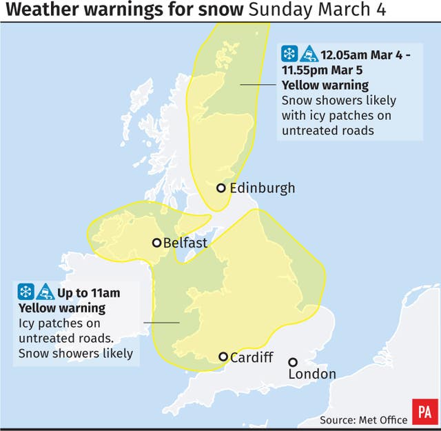
A Met Office warning is in place for further snow throughout Saturday and into the evening for parts of northern England and Scotland, with overnight lows of minus 3 to minus 4C in rural areas.
This could become more persistent in parts of Scotland, with a further warning in place for all of Sunday and Monday.
An orange weather alert for lying snow and ice remains in four areas of Ireland.
As remnants of Storm Emma continue to bring bands of sleet, snow and rain over the weekend, 12 flood warnings and 33 alerts are in place, predominantly for south-west and north-east England coastal areas.
But as the snow begins to melt, it risks turning to ice overnight, with a Met Office warning in place for the South and Northern Ireland until 11am on Sunday.
Met Office forecaster Becky Mitchell said: “Through the rest of tomorrow afternoon we’ve got spells of rain across the South, perhaps turning to sleet at times, but we really are losing that risk of snow across much of southern England and Wales through Sunday as temperatures return towards normal for a lot of places.
“There is quite a lot of snow in some places across the South…so it’s going to be some time before all that snow melts away but temperature-wise over the next few days it’s definitely going to help things.
“The main point is it’s gradually turning milder so we are seeing an end to widespread cold conditions from this weekend onwards.”
After the extreme #weather many of us have seen recently, conditions will ease a little through the next few days. More information here: https://t.co/qWebLWaczh pic.twitter.com/IsgTE6z5PI
— Met Office (@metoffice) March 3, 2018
The milder weather spells the end of frozen rain – the rare weather phenomenon seen recently which occurs when snow, ice, sleet or hail passes through warm air before cooling closer to the ground and freezing on impact.
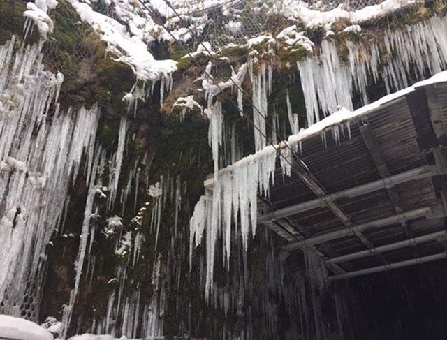
But there are still hazards even as the forecast improves.
Oooo be careful from above! #NYFRS crews across the county are being called out to numerous icicles hanging in a threatening manner from buildings!
— North Yorkshire Fire (@NorthYorksFire) March 3, 2018
Northern Powergrid restored power to 12,000 households in Humberside and north Lincolnshire after freezing rain and high winds overnight, with around 3,500 still without power through Saturday.
Outages across the North West and north Wales were also fixed for tens of thousands of homes.
London Fire Brigade said it took 375 flooding calls in London on Friday night – many for pipes that had frozen.
Last night we took 375 flooding calls pan London – many were for #frozenpipes. Please keep 999 for emergencies and call a plumber for plumbing problems. https://t.co/PX40aXsYEJ
— London Fire Brigade (@LondonFire) March 3, 2018
Those experiencing the problem in Yorkshire were urged to use a hairdryer to gently thaw the blockage.
On Saturday, icicles caused damage to overhead cables in Bishopton tunnel in Scotland, while North Yorkshire Fire and Rescue knocked down dangerous shards of ice overhanging a footpath.
The RAC said driving conditions were still treacherous across vast swathes of the UK, urging caution, as some main routes previously rendered impassable were reopened.
Overnight, the M62 in Greater Manchester finally started moving after being closed for more than a day.
Drivers are being urged to return to their vehicles in areas where it is safe to, after hundreds were abandoned.
Some roads, such as the A66, remain closed on Saturday as authorities work to clear snow.
Widespread delays remain as airports reopen and train routes resume, while many operators run a reduced service and ScotRail continues to advise customers not to travel.


Comments: Our rules
We want our comments to be a lively and valuable part of our community - a place where readers can debate and engage with the most important local issues. The ability to comment on our stories is a privilege, not a right, however, and that privilege may be withdrawn if it is abused or misused.
Please report any comments that break our rules.
Read the rules here